
Staying Prepared for Tsunamis
What is a tsunami?
When an earthquake occurs under the seafloor, the seafloor rises and sinks, and the overlying water is rapidly pushed up and down over a wide area in a short period of time. This causes a great rise and fall of the sea surface, generating a series of waves which turn into tsunami waves.
How tsunamis work
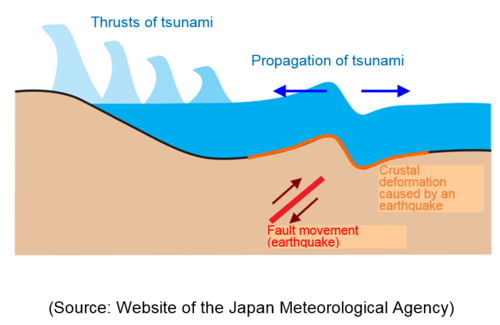
Fault movement (earthquake) under the seafloor causes crustal deformation, pushing up the overlying water. This mass of uplifted water produces tsunami waves which spread out in all directions in the sea.
What is the difference between wind waves and a tsunami?
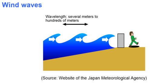
Wind waves are a phenomenon produced by winds blowing over the sea, and occur near the sea surface. Their wavelength (the length between wave crests or troughs) ranges from several meters to hundreds of meters.
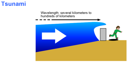
Meanwhile, a tsunami is the propagation phenomenon of sea waves produced as a consequence of the rise and fall of the sea surface that are generated when the seafloor is deformed by an earthquake or other seismic activity, vertically displacing the overlying water over a wide area of sea in a short period of time. The wavelength of a tsunami is very long, from several kilometers to hundreds of kilometers. This means that massive amounts of water welling up from the seafloor to the surface sweep into coastal areas.
Tsunami waves hit coastal areas repeatedly without losing their power, and rise up to a higher elevation than themselves at the coast. Tsunami waves also suddenly become higher when approaching a shallow coast. Moreover, when they recede, they continue receding for a long period of time, maintaining their strength. Accordingly, damaged houses and other floating objects are pulled into the sea all at once.
(Source: Website of the Japan Meteorological Agency)
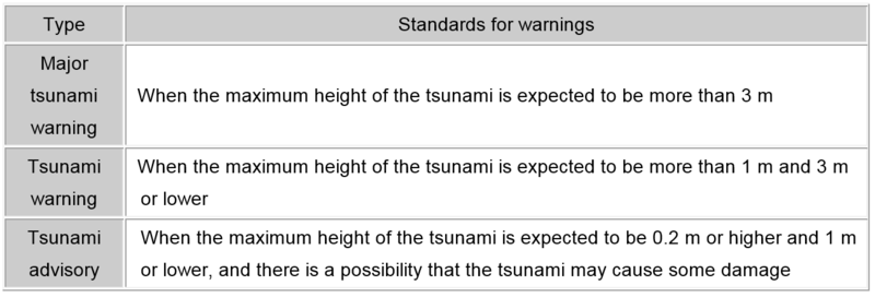
What is the difference between a tsunami warning and a tsunami advisory?
When an earthquake occurs, the Japan Meteorological Agency promptly estimates its size and location, and based on these, calculates how high the tsunami will be at the coast to announce a major tsunami warning, a tsunami warning, or a tsunami advisory within approximately three minutes after the occurrence of the earthquake.
Five tips to stay safe from a tsunami
Even if a tsunami occurs, you can potentially reduce the damage it causes if you respond quickly and evacuate early. To stay safe from a tsunami, please follow the five tips below:
- Obtain accurate information from TV and radio.
- When a tsunami advisory, tsunami warning, or major tsunami warning is announced, move away from the coast and rivers immediately, and evacuate to a safe place, such as high ground, quickly.
- If you have difficulty evacuating to a safe place (such as high ground), evacuate to a substantial building or an emergency evacuation facility protected from flooding near you.
- If it is too dangerous to go outdoors, evacuate to a safe place indoors (an upstairs room).
- Since tsunamis come ashore repeatedly, keep away from the coast and rivers by all means until the tsunami advisory, tsunami warning, or major tsunami warning is lifted.
Target areas for evacuation notices
In principle, when a tsunami advisory, tsunami warning, or major tsunami warning is announced by a meteorological observatory, the city will issue an evacuation notice to areas requiring evacuation.
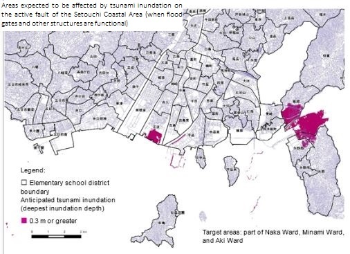
Target areas for an evacuation notice
Tsunami Advisory
Tsunami Warning
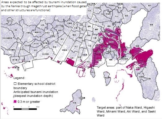
Source: Report for Anticipated Damage from an Earthquake in Hiroshima Prefecture (October 2013)
- Note 1: Target areas are those where the deepest depth of inundation is expected to be 30 cm or greater.
- Note 2: Target areas include those located on the sea and river sides of embankments.
- Note 3: If river and sea authorities notify the city that flood gates or other structures are malfunctioning, the city will disseminate and issue evacuation information to areas requiring evacuation, referring to the Hiroshima Prefecture Map of Anticipated Inundation by Tsunami.
- Note 4: When a major tsunami warning is announced, the city will determine the target areas requiring evacuation based on the announced height of the tsunami.
- Note 5: When a tsunami advisory is announced after the impact of a tsunami caused by an earthquake that occurs abroad is announced as Distant Earthquake Information, the city will issue an evacuation notice to the areas shown on the Tsunami Advisory Map above, in principle. However, if it is deemed that there is no risk of inundation by a tsunami as a result of the collection of information related to tsunami and tide levels, the city will deliberate as to whether evacuation information should be issued and the content of evacuation information.
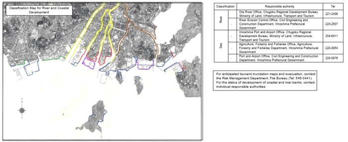
Supervisory authorities responsible for developing coastal and river banks in the city are shown on the map. For the status of development, please contact the individual supervisory authorities.
Inquiries regarding this page
Disaster Prevention Division, Crisis Management Office
1-6-34 Kokutaiji-machi, Naka-ku, Hiroshima
Tel: 082-504-2664 / Fax: 082-504-2802
Mail: [email protected]