
Emergency Evacuation Info/Guide App "Hiroshima Emergency Evacuation Guide"
About the App
The Emergency Evacuation Guide app was developed to alert users of the appropriate evacuation measures to take before disasters occur. When evacuation information is issued, the app will guide you to your closest functioning emergency evacuation shelter.
When emergency information is announced for your current location, the app will display an evacuation route to your closest functioning emergency evacuation shelter with just one tap, making it easy for those who are unfamiliar with Hiroshima City (including visitors and those who commute to Hiroshima for work or school) to quickly and easily find shelter nearby in a visual format.
The app also includes multilingual support for emergency information in three languages (English, Chinese, Korean), as well as hazard information presented for your current location on the map.
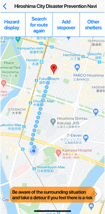
The app can also be used when there is no emergency information available: check the weather and information from the City of Hiroshima, search for emergency evacuation shelters, learn the route from your house to shelters in your area, and stay prepared for disasters and emergencies.
Download the App
For iPhone (iOS) Users
iPhone users can download the app in the link below.
![]()

(Recomended version: iOS 10.0 or above)
For Android Users
Android users can download the app in the link below.
![]()

(Recommended version: Android 6.0 or above)
Download Fees
Free (any mobile data fees incurred through the use of the app will fall to the user)
Primary Features of the App
Evacuation Support in Emergencies
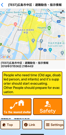
When evacuation information is announced for the area you’re in, the app will display a route to your closest functioning emergency evacuation shelter based on GPS information.
The route map can be also customized to avoid dangerous areas based on hazard information (using the Add Stopover function), and you can search for new routes at any time.
Note: be sure to pay attention to your surroundings (not just your phone) when using this app to evacuate during an emergency.
Note 2: This app uses mobile data and GPS information. As the accuracy of GPS readings depend on the environment around you, there may be a slight lag/discrepency between your displayed position and your actual position.
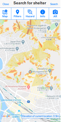
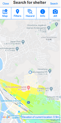
High-Risk Areas (Hazard Map)
The map displays high-risk areas (hazard information), including areas prone to landslides, flooding, tsunami, high tides, etc, in real-time.
Emergency Information
The app also notifies you about the latest evacuation information (warning levels), civil protection information, and weather information.
Other Features
- Guide to services to confirm the safety of family members, etc
- Multilingual Support (English, Chinese (simplified/traditional), Korean, Japanese)
- Links to various critical infrastructure information
- Live streams of emergency camera video footage
Inquiries regarding this page
Disaster Management Office, Disaster Prevention Division
1-6-34 Kokutaiji-machi, Naka-ku, Hiroshima
Tel: 082-504-2356 / Fax: 082-504-2802
Mail: [email protected]
PDFファイルをご覧いただくには、「Adobe(R) Reader(R)」が必要です。お持ちでない方はアドビシステムズ社のサイト(新しいウィンドウ)からダウンロード(無料)してください。