
Staying Prepared for Heavy Rains and Typhoons
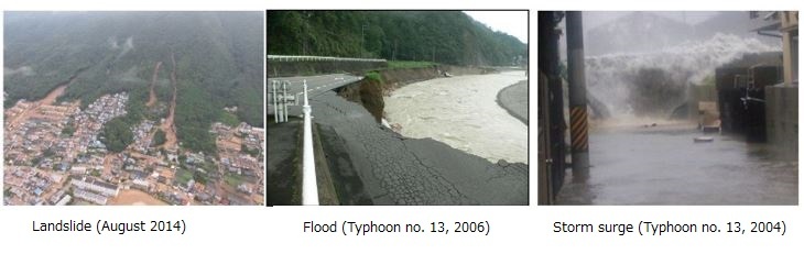
Hiroshima City is blessed with an abundance of nature (the sea, mountains, and rivers), however, these blessings also put it at a high risk for natural disasters. Heavy rains brought by seasonal rain fronts and typhoons have, in the past, caused a number of natural disasters in Hiroshima, such as landslides, floods (overflowing in rivers), and storm surges.
Quick guide to staying safe during heavy rains and typhoons
When heavy rain or typhoon is approaching, be sure to stay prepared by following the instructions below:
- Regularly check weather forecasts (radio, TV, internet, etc)
- Have things ready to take in case of an evacuation, such as food, water, regular medicines, and valuables. As there may be power or gas outages, be sure you have enough essential supplies for at least three days (one week if possible).
- Learn where your local emergency evacuation shelters are (ask your local ward office/fire stations, check online, etc).
- Have flashlights and a radio ready in case of a power outage.
- Items such as flowerpots and laundry poles may be blown away. Keep them inside or secure them so they cannot move.
- Take part in community disaster drills to stay prepared.
- Download the Hiroshima City Emergency Evacuation Guide App.
-
Have things ready to take in case of an evacuation (PDF 524.5KB)

- Emergency Evacuation Info/Guide App "Hiroshima Emergency Evacuation Guide"
Damages caused by heavy rains and typhoons
|
Casualties Dead |
Casualties Missing |
Casualties Injured |
Houses damaged Completely destroyed |
Houses damaged Seriously damaged |
Houses damaged Partially damaged |
Houses damaged Flooding above floor level |
FHouses damaged looding below floor level |
|
|---|---|---|---|---|---|---|---|---|
|
June 1999 (Torrential rain disaster on June 29) |
20 |
0 |
45 |
74 |
42 |
85 |
183 |
392 |
|
September 2004 (Typhoon No. 18) |
1 |
0 |
60 |
0 |
6 |
6,004 |
64 |
122 |
|
September 2005 |
0 |
0 |
3 |
3 |
72 |
0 |
119 |
117 |
|
September 2006 |
1 |
1 |
2 |
0 |
1 |
27 |
13 |
43 |
|
July 2010 |
0 |
0 |
0 |
0 |
0 |
1 |
31 |
566 |
|
August 2014 |
77 |
0 |
68 |
179 |
217 |
189 |
1,084 |
3,080 |
|
July 2018 |
23 | 2 | 30 | 171 | 421 | 152 | 1,324 | 1,022 |
Staying safe in times of emergency relies on staying prepared in your everyday life.
How to stay safe when natural disasters happen
When it comes to staying safe when natural disasters happen, instead of overly relying on municipal government, you should act in order to keep yourself safe. Don't fall into the assumption that you won't become a victim of a natural disaster: evacuate at your own discretion.
When there is a high risk that a natural disaster will occur, the City of Hiroshima will issue evacuation information for areas which are most likely to be affected.
However, evacuation/emergency information is issued to broad areas of the city, and not towards individual residents. There may also be times when disasters occur suddenly, leaving little or no time to issue evacuation information.
This is why it's necessary for you to be the judge of when to evacuate. Understand that based on the geography of where you live, the structure of your home, and the members of your family, your own evacuation measures and timing may differ. Be sure to check and be sure of factors such as if you live in an area which may be forced to evacuate in an emergency, or if you can stay safe on a higher floor in your home, and act accordingly.
Which areas are at risk?
High-risk areas are designated by the national and Hiroshima Prefectural governments according to laws and regulations. The first step to staying prepared is to check what kind of natural disasters your neighborhood/workplace is at risk for. You should also be sure to check the expected amount of flooding should a flood or storm surge occur in your area.
Please note, however, that designated high-risk areas are not the only places which are vulnerable to natural disasters.
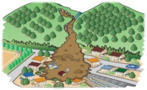
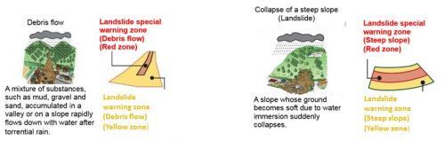
Landslides
Most areas of the city are located in the weathered granite zone (commonly known as decomposed granite) where the soil is less viscous and well-known for becoming prone to instability and collapse when it absorbs water.
This makes many areas in Hiroshima City particularly prone to landslides.
While we are currently working on hard infrastructure measures, such as constructing sand control dams, it will take time and money to ensure that all high-risk areas are safe. Therefore, in the meantime, we ask that you know where the high-risk areas are in your neighborhood, and evacuate accordingly.
Areas prone to landslides have been designated and made public by Hiroshima Prefecture as Landslide Warning Zones, as prescribed in Article 7 of the Sediment Disaster Countermeasures for Sediment Disaster Prone Areas Act. Currently, more areas of the city are in the process of being designated as landslide warning zones. For more details, please refer to the Landslide Prone Area Map put out by Hiroshima Prefecture in 2002.
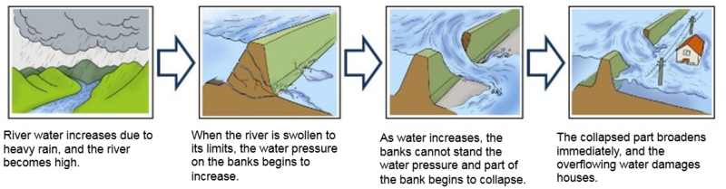
Floods
The urban area of Hiroshima City, built along the Ōta-gawa River system, has a long history of flood damages. Even today, while we continue with bank protection works, there is still a risk of flooding when precipitation is more than expected. Small and medium-sized rivers also run the risk of flooding due a sudden increase in water level due to torrential rains.
Areas expected to be affected by flooding (overflowing in rivers) have been designated and made public by national and prefectural river authorities based on Article 14 of the Flood Control Act.
In Hiroshima City, the following areas have been designated and announced as areas expected to be affected by flooding (overflowing in rivers) as of the end of FY 2016: the Ōta-gawa River, the Nenotani-gawa River, the Misasa-gawa River, the Tenma-gawa River, the Former Ōta-gawa River, the Motoyasu-gawa River, the Furu-kawa River, the Yasu-kawa River, the Minochi-gawa River, the Fuchū-Ōkawa River, the Suzuhari-gawa River, and the Nabara-gawa River; the Seno-gawa River of the Seno-gawa River system; the Yahata-gawa River of the Yahata-gawa River system; and the Okanoshita-gawa River of the Okanoshita-gawa River system.
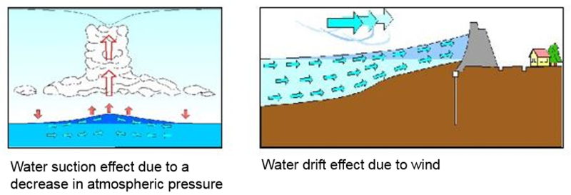
Storm surges
Storm surges are caused by an elevation in sea level associated with a decrease in atmospheric pressure and strong winds during a typhoon or other extreme weather conditions.
Hiroshima Bay is a U-shaped bay that opens to the south, which makes it prone to storm surges. On top of that, the urban areas on the delta are located on low-lying ground, which means that should a typhoon occur during high tide, the city runs a high risk of extensive flood damages.
With all of these risk factors, the national and prefectural governments are involved in protective measures such as raising and fortifying sea walls; however, residents who live near the coast should be especially vigilant and aware of storm surges.
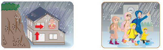
In the event of an evacuation
If your home is located in an area where there is a high risk of natural disaster, you must move to a safe place (somewhere outside of the danger zone, a higher level in your home than expected flooding, etc) to protect yourself and your family.
More specifically speaking, evacuate to places such as the home of a friend or relative, or your local community assembly hall. The City of Hiroshima will also establish emergency evacuation shelters depending on the type of emergency/natural disaster.
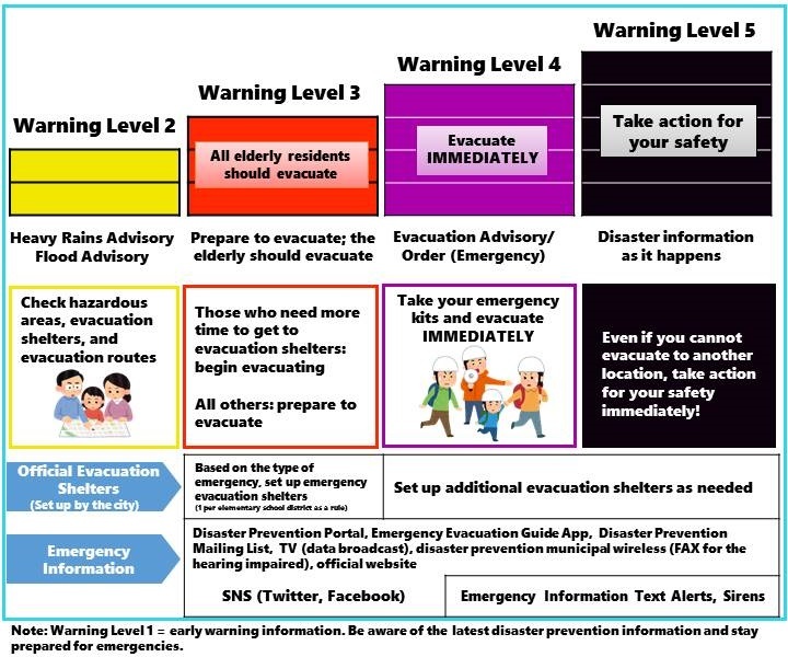
Below you’ll find a chart which details the establishment of evacuation sites depending on the Warning Level issued.
Please be aware that emergency evacuation sites will not all be made available to the public at once: once an emergency evacuation site has been opened, the City will announce details via the Hiroshima City Emergency Evacuation Guide App, SNS (Twitter/Facebook), official website, etc.
|
Warning Level |
Evacuation Shelters |
|---|---|
|
Warning Level 3: Evacuation preparation/evacuation of the elderly and those who need more time to evacuate |
In principle, one designated emergency evacuation shelter will be established as a hub facility in the elementary school district. |
|
Warning Level 4: Evacuation Warning/Order (Emergency) |
Evacuation shelters will be established as needed according to the situation. |
When should I evacuate?
Weather information, such as heavy rain warnings, is announced by the Japan Meteorological Agency, whereas information about river water levels is announced by river authorities. The City of Hiroshima then takes this information and uses it to announce evacuation information (evacuation warnings, etc) to help our residents make safe and smart choices about evacuation.
We ask that you take all of this information into account and make an emergency plan of when to evacuate based on your own individual circumstances, such as family make up and where you will evacuate to.
When it comes to evacuation information, we recommend downloading the Hiroshima City Emergency Evacuation Guide App as well as checking the Disaster Preparedness Portal, both of which provide up-to-date emergency information as it becomes available.
- Emergency Evacuation Info/Guide App "Hiroshima Emergency Evacuation Guide"
-
Disaster Preparedness Portal(External link)
What should I take with me when evacuating?
Be sure to prepare an emergency evacuation kit which has survival essentials (food, water, regular medicine, etc) for at least three days (if possible, one week) to take with you when you evacuate.
If evacuating to a higher level in your house than expected flooding, you should be prepared for the possibility of spending a prolonged period of time in your home should the flooding continue, and for the possibility of isolation, both of which can lead to difficulties in obtaining food, water, and medical care. Be sure to keep a stock of necessary items, including light sources, and bring them with you when you evacuate to a higher level in your home.
In the event of a large-scale earthquake, it is possible that the supply chain of goods may be disrupted due to widespread damages, making it difficult to purchase necessary items. However, as damages from landslides and floods are relatively localized, it may be possible to obtain everyday necessities from stores near your evacuation shelter.
Disaster preparedness in your community
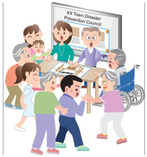
Evacuation measures and timing will differ depending on where you live; however, as the rain conditions, disaster risks, geographical features, and evacuations are similar among your neighbors and neighboring areas, cooperation within the local community for disaster preparedness is not only important, it’s also effective.
In the mid-1980s, voluntary disaster prevention organizations began to be established at the neighborhood/resident association-level in Hiroshima City, and currently, these voluntary disaster prevention organizations cover the entire city and are in charge of activities such as creating disaster prevention maps for different localities, holding emergency/disaster drills, as well as disaster preparedness seminars.
Learn about what your community is doing for disaster preparedness, and what you can do to be a part of it. Remember, knowledge is the key to staying prepared and staying safe.
Inquiries regarding this page
Disaster Prevention Division, Crisis Management Office
1-6-34 Kokutaiji-machi, Naka-ku, Hiroshima
Tel: 082-504-2664 / Fax: 082-504-2802
Mail: [email protected]
PDFファイルをご覧いただくには、「Adobe(R) Reader(R)」が必要です。お持ちでない方はアドビシステムズ社のサイト(新しいウィンドウ)からダウンロード(無料)してください。